TROPICAL STORM HENRI UPDATE…
TROPICAL STORM WARNING: ALL OF NYC, SW CONNECTICUT, SOUTHEASTERN WESTCHESTER CO., NORTHEASTERN NJ, NASSAU COUNTY, NY, AND SUFFOLK COUNTY
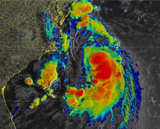
Henri has been downgraded to a tropical storm and, according to the latest track, will likely make landfall in Rhode Island late Sunday morning and then track into southern New England later today into Monday as it weakens.
The main threats from Henri are potentially life-threatening storm surge (anywhere from 2-4 feet especially along the Long Island Sound), heavy rain capable of producing flash flooding, tropical storm or hurricane force wind gusts along extreme eastern Long Island and across southern Connecticut. There will also be associated marine and coastal hazards, including very rough seas and dangerous rip currents.
Severe beach erosion is possible for coastal areas of Long Island Sound and portions of Suffolk County, including the Twin Forks region.
A widespread swath of rain between 2-5 inches is forecast in the path of Henri with localized higher amounts possible through Sunday night. The highest amounts are forecast to be across Long Island and much of southern Connecticut and will occur along and west of the center of Henri. This will present a likelihood for areas of flash flooding.
WINDS SUNDAY:
NYC, SOUTHEASTERN NY AND NJ: 10-20 MPH WITH SOME GUSTS 30+
LONG ISLAND:
NASSAU COUNTY: 15-25 MPH WITH GUSTS 40+ POSSIBLE
SUFFOLK COUNTY: 25-40 MPH WITH GUSTS NEAR 60+ MPH POSSIBLE, ESPECIALLY OUT ON THE VERY EAST END
RAINFALL TOTALS: 2 TO 5 INCHES IN GENERAL, WITH LOCALLY HIGHER AMOUNTS POSSIBLE
COASTAL STORM SURGE: 2 TO 4 FEET POSSIBLE WITH MODERATE TO SIGNIFICANT FLOODING AT TIMES OF HIGH TIDE
CONDITIONS SHOULD BEGIN TO IMPROVE IN MOST AREAS TONIGHT BUT WINDS WILL STILL BE FAIRLY GUSTY WITH OCCASIONAL SHOWERS.
EXPECT PARTLY TO MOSTLY CLOUDY SKIES MONDAY WITH SCATTERED SHOWERS AND THUNDERSTORMS DEVELOPING AS THE REMNANTS OF HENRI SPIN TO OUR NORTH.
MORE UPDATES WILL FOLLOW THROUGHOUT THE DAY.
FOR A FULL HURRICANE PREPAREDNESS CHECKLIST, CLICK HERE
RADAR PHOTO CREDIT: NOAA